
Flying Turtle Drone Videography
The World Looks Better from Above!
Frank Boston has been an FAA Certified Remote Pilot since 2018. He purchased his first drone in 2014, and has been flying ever since. He has flown professionally for the State of Michigan; for this business; and for his own enjoyment. You'll love seeing how the world looks from the air! Let Flying Turtle Drone Videography show you what can be seen!
NOTE: This website is under construction.
Not all web features work yet, but everything you want to know is on this screen.

Most video shot in 4K or 2K (not shown in YouTube video)
Sample Projects

Sparrow Eaton: Al!ve
Charlotte, Michigan

The Country Mill
Charlotte, Michigan

Saint Mary Church
Charlotte, Michigan

Historic 1885 Courthouse Museum
Charlotte, Michigan

Residential Homestead
Mount Pleasant, Michigan area

Vacation Spot
Neebish Island, Michigan
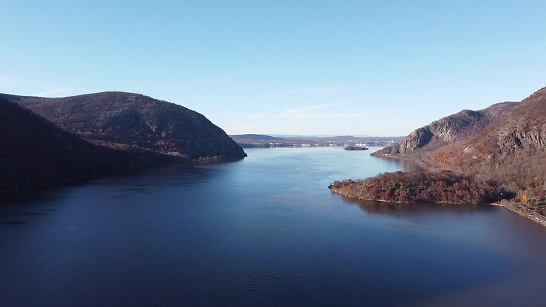
The Hudson River
Cold Spring, New York
Your Project
Each project is different - Your site is special!
Whether your property is residential, commercial, or agricultural or wooded, seeing it from above can give you insight and show its true beauty
Note that outdoor flights are weather-dependent, so specific dates may not always work. Also, aerial restrictions may apply in some areas, especially near airports and other infrastructure. No worries; Flying Turtle Drone will work with you to plan and execute each project successfully.
Contact Flying Turtle Drone Videography to discuss options. Here are some ideas.

Residential Property (small)
Single main building
Typically 1/2 acre or less
This option is designed for homeowners and realtors who want a special view of the property
Birdseye "nadir" image showing full property, plus 8 compass-point images at suitable elevation: $50
360-degree video circling building at suitable altitude above ground level: $50
Dynamic video, typically with approach and rise over building: $50
Custom products as requested: Negotiable
Finalized edited video & photos: add $50

Residential Property (large)
Single main building
Typically up to 1 acre
This option is designed for homeowners and realtors who want a special view of the property
Birdseye "nadir" image showing full property, plus 8 compass-point images at suitable elevation: $60
360-degree video circling building at suitable altitude above ground level: $60
Dynamic video, typically with approach and rise over building: $50
Custom products as requested: Negotiable
Finalized edited video & photos: add $50

Commercial Property (small)
1 or more buildings
2 acres or less
This option is designed for smaller commercial properties who want all encompassing aerial view(s) of the property. The goal is typically to showcase the property or the operation's product(s).
Birdseye "nadir" image showing full property, plus 8 compass-point images at suitable elevation: $75
360-degree video circling building at suitable altitude above ground level: $75
Dynamic video, typically with approach and rise over building: $75
Custom products as requested: Negotiable
Finalized edited video & photos: add $100

Commercial Property (medium)
Typically several buildings
2 to 10 acres
This option is designed for mid-sized commercial properties who want all encompassing aerial view(s) of the property. The goal is typically to showcase the property or the operation's product(s).
Birdseye "nadir" image showing full property, plus 8 compass-point images at suitable elevation: $85
360-degree video circling building at suitable altitude above ground level: $85
Dynamic video, typically with approach and rise over building: $85
Custom products as requested: Negotiable
Finalized edited video & photos: add $150

Agricultural Property (medium)
2 or 3 main buildings
Up to 10 acres
This option is designed for mid-sized agricultural operations who want all encompassing aerial view(s) of the property. The goal is typically to showcase the property or the agricultural product(s).
Birdseye "nadir" image showing full property, plus 8 compass-point images at suitable elevation: $85
360-degree video circling building at suitable altitude above ground level: $85
Dynamic video, typically with approach and rise over building: $85
Custom products as requested: Negotiable
Finalized edited video & photos: add $125

Large Projects
Any number of buildings
Larger than 10 acres
This option is designed for large operations of any type, commercial, agricultural, municipal, etc. The goal is typically to showcase the property or the products of the operation.
All products as listed in previous options are possibilities
On-site visit may be required before quoting price options
Contact info
Frank Boston
FAA Certified Remote Pilot
Charlotte, Michigan
517-618-1471
